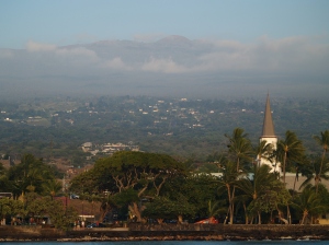
Evening Sunshine Glows on Old Kailua Town: Photo by Donnie MacGowan
The town of Kailua Kona is the crown jewel on the island of Hawaii and the beating heart of the Kona Coast. A sleepy fishing village not so long ago, Kailua Kona is now the metropolitan center of West Hawaii’s burgeoning economy and exploding population. Founded by King Umi in the 1500’s, Kailua Kona served as the social, religious and political capital of Hawaii for several hundred years. Deeming it the loveliest spot in all the Hawaiian Islands, King Kamehameha the Great ruled his island empire during the final years of his reign from here.
Exploring the downtown area from the King Kamehameha Beach Resort to the Honl’s Beach on the south provides a couple hours pure enjoyment: easy walking along the incomparable turquoise Kona Coast under the warm, sapphire Hawaii sky, past ancient temples, missionary churches, intriguing and unique shops and wonderful restaurants. It is easy, walking here, to understand how one can be completely seduced by the magic of the Big Island.
Kailua Kona is a town made for walking, so start by parking your car. On the north side of town, abundant for-pay parking is available at the King Kamehameha Beach Hotel. Free parking on this end of town is available at Triangle Parking, between Kuakini Highway and Ali’i Drive. About half-way through town, by the Farmer’s Market and Hale Halawai Park, is a large area of free parking. On the south side of town there is abundant free parking at the Coconut Grove shopping area, and at Honl’s Beach.
Let’s start exploring Kailua Kona on the north and work our way south. The thatched structure surrounded by carved wooden idols across from the pier is ‘Ahu’ena Heiau, an ancient and sacred temple site. A temple (or Heiau) has existed on this spot since at least the first millennium, and as recently as the 15th century was occupied by a temple of human sacrifice (or luakini Heiau) dedicated to the war god Kuka’ilimoku. In 1812, King Kamehameha I ordered the heiau enlarged, rebuilt, rededicated as ‘Ahu’ena Heiau (“hill of fire”), a temple of peace and prosperity dedicated to the fertility god Lono.
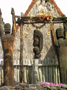
Ahu'ena Heiau, Kailua Kona: Photo by Donald MacGowan
The current structures seen at ‘Ahu’ena Heiau were re-built in 1975 under the auspices of the Bishop Museum with financial help from the Hotel King Kamehameha and are constructed to 1/3 the original scale. Here, there is a veritable forest of of carved, wooden sacred images in the “Kona Style”, considered the most refined in all Polynesia. More about Ahu’ena Heiau can be found, here.
Three delightful, but tiny, beaches grace the immediate downtown area; from north to south they are named Kamakahonu, Keakaiakua and Niumalu–many locals do not even know thy have names. The snorkeling from these small beaches is spectacular and strangely uncommon. A beautiful coral garden and vibrant reef fish can be seen snorkeling along the shoreline off ‘Ahu’ena Heiau where fish, turtles and eels are abundant in Kailua Bay. More about the history of these beaches, the pier and seawall and Old Kailua Village can be found here.
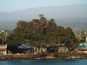
Pao Umi Rock and the Moreton Fig Tree in Kailua's Evening Light: Photo by Donnie MacGowan
Pa’o Umi, a point of rock between the pier and Hulihe’e Palace and mostly buried under Ali’i Drive, is where High Chief Umi is thought to have landed when he moved his court from Waipi’o Valley to Kailua in the 1500’s. Umi consolidated and centralized religious and secular power of Hawai’i Island in Kona and built a number of temples, most notably on the current sites of Ahu’ena Heiau, Moku’aikaua Church and Kona Inn. Umi founded the political landscape which ultimately fostered King Kamehameha’s regime and led to the unification of the Hawai’ian Islands into a single nation.
Across Ali’i Drive from Pa’o Umi is a large Moreton Fig tree that appears in photographs of downtown Kailua since before the turn of the last century; as such, this tree is at least 140 years old.

Mokuaikawa in Kailua Kona; the First Christian Church in Hawaii: Photo by Donald B. MacGowan
During the winter of 1819 to 1820, Congregationalist missionaries from Boston crossed the Atlantic Ocean enduring 5 months of intense stormy weather while headed for a new life in Hawai’i. In March of 1820, the missionaries sailed into the balmy waters of Kailua Bay and landed at Kamakahonu Rock (eye of the turtle”), the “Plymouth Rock” of Hawai’i, which now supports the Kailua Pier..
Mokuaikaua Church, built under the leadership of missionary Asa Thurston between 1835 and 1837, was specifically aligned so that the prevailing breezes would pass through it, but also so that it presented a strong, stone façade to the south and west, the direction from which strong Kona Winds, large storms and hurricanes come. The 112-foot steeple was for many decades the highest structure in Kailua and served as a navigation landmark both for ships at sea and people on land.
The church is constructed of rough-hewn basalt blocks mortared with lime made from burnt coral and bound with kukui nut oil. The corner stones were taken from a heiau built on the same spot by King Umi in the fifteenth century. The interior beams and woodwork are of koa wood. The joints were painstakingly joined with ohi’a wood pins; this is a magnificent example of the architectural style brought to Hawai’i by the missionaries in the 19th century.
The inside of the church is beautiful, cool and inviting, and visitors are welcome between services and on weekdays between sunrise and sunset; admission is free. There is a fascinating mini-museum, small but informative, which is open daily from sunrise to sunset and free tours are conducted from 10 a.m. to noon and 1 to 3:30 p.m. The Museum features exhibits about Hawai’i, the life of the missionaries and contains a scale model of the Brig Thaddeus. More about Mokuaikawa Church and it’s fascinating history, can be found here .
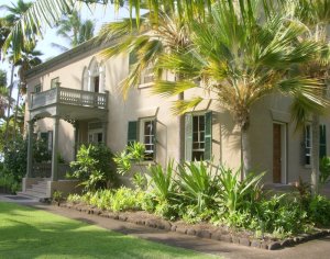
Hulihe'e Palace, Kailua Kona Hawaii: Photo by Donnie MacGowan
Hulihe’e Palace was built by High Chief (later Governor) James Kuakini in 1838 as a home. For many years, the Palace was used by Hawai’ian royalty as an official residence and summer get-away palace, a place of great galas and parties, but was abandoned to ruin in 1914. Since 1928 the Palace has been operated as a museum by the Daughters of Hawai’i. The Palace Gift Store has many fine art items and hard-to-find books on Hawai’iana.
The museum is open Monday-Friday, 9 a.m. to 4 p.m. and Saturday and Sunday, 10 a.m. to 4 p.m. There are friendly and knowledgeable docents who give free tours, which last about 45 minutes. Admission is $5 for adults, $4 for seniors and $1 for students; photographing inside the museum is forbidden. The palace sustained considerable damage during the earthquake of 2007 and is currently undergoing renovation. More about Hulihe’e Palace can be found here.

Kona Inn Shops: Photo by Donald B. MacGowan
The Kona Inn is of particular historic significance, as it was the first destination resort to open in West Hawai’i and it ushered in the era of tourism along the Kona Coast. Built on the site of Papa ‘Ula (red flats) where a temple of human sacrifice was built by High Chief Umi, today the Kona Inn features many unique and interesting shops and fine restaurants.
The Inn fronts on a large, palm-shaded lawn that leads to a seawall and the ocean. This area is open to the public and is a really grand place for picnicking, watching whales and dolphin and the fabulous Kona sunsets.
The Kailua Farmer’s Market, open Wednesday through Sunday, lies in the parking lot at the corner of Ali’i Drive and Hualalai Road between the Public Library and Hale Halawai Park. The market offers a wide and intriguing variety of fresh produce, hand-made local arts and crafts, Hawai’iana and other types of souvenirs.

Kailua Farmer's Market: Photo by Harvey Bird Watching
The grounds and oceanfront of Hale Halawai Park offer a peaceful, shady place for taking a rest from a busy tour of bustling downtown Kailua, or watching whales and dolphin and the unmatched Kona sunsets. Frequently honu (sea turtles) and boogey boarders can be watched from the seawall. Featuring coconut palms, a neatly manicured lawn, picnic tables and a seawall, the large, Polynesian-style pavilion is used for everything from community gatherings to orchid shows to wedding receptions.
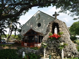
Saint Michael the Arch Angel Catholic Church, Kailua Kona Hawaii: Photo by Donnie MacGowan
Historic St. Michael’s Church was the first Catholic Church in West Hawai’i. The church offers services in English and Spanish throughout the week, but is primarily of historic interest; the burial plots in the cemetery date from 1855. In 1940, during less “ecologically aware” times, resident priest Father Benno Evers had his parishioners gather 2500 coral heads to build the grotto in front of the church, which covers the church’s original well. The seafloor in Kailua Bay has yet to recover from this pillaging of coral heads.
Coconut Grove and Waterfront Row cap the southern end of the Kailua Village shopping district along Ali’i Drive, starting next to the Hale Halawai County Park and ending at the Royal Kona Resort. Newer and more metropolitan that its sister shopping district to the north, Coconut Grove and Waterfront Row have almost everything, from tattoos to souvenirs to Hawai’iana, fine art, musical instruments, sundries, groceries and clothing. The range of cuisines available from restaurants here sweeps from local flavor to Thai, the Hard Rock Cafe to poi crepes to pizza and burgers
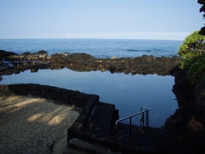
Public Queensbath Tidepool: Photo by Donald B. MacGowan
Between the Royal Kona Resort and Hale Kona Kai Resort is a fabulous tide pool that is completely protected from all but the most vicious winter surf. It boasts a moderate population of reef fish and even the occasional turtle! The water sometimes can be a bit murky, but it makes a nice place to take small children or beginning snorkelers. Drive into the entrance for the Royal Kona Resort and continue south past it until you see the blue and white Shoreline Access sign; find a place to park, go down the stairs to the tiny beach and enjoy!
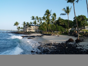
Honl's Beach in Kailua Kona: Photo by Donald B. MacGowan
Lovely but compact, Honl’s County Beach Park is a small beach on the southern outskirts of Old Kailua Town. A favorite spot for surfers and boogie boarders it also has very nice snorkeling and is an excellent place to view the sunset and picnic. Remember when going into the water here, there is a fairly strong current to the north, so stay in the shallow reef area close to the beach. Parking is located on both sides of Ali’i Dr., but can be tight here in times of good surf, and crossing Ali’i Dr. drive can be a bit dangerous at certain times of the day. A new bathroom with showers and running water has recently been constructed on the mauka—uphill–side of the road.
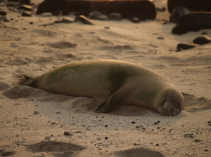
Monk Seal on Honl's Beach at Sunset: Photo by Donald B. MacGowan
For details on a scenic drive through the Keauhou Historic District south of Kailua Kona on Ali’i drive, please go here. To get details on visiting and snorkeling Kailua Kona’s famous Kahalu’u beach, where all the turtles are, please go here. For detailed information on a scenic drive through Up County Kona, please go here. Information about the ancient villages, temple ruins, amazing beaches and fabulous hiking trails of Koloko Honokohau National Historic Park just north of Kailua Kona, please go here.
To see the new iPhone/iPod Touch App, please visit http://www.tourguidehawaii.com/iphone.html. The best of Tour Guide Hawaii’s free content about traveling to, and exploring, the Big island, can be found here.
For more information on traveling to Hawaii in general and on touring the Big Island in particular, please also visit www.tourguidehawaii.com and www.tourguidehawaii.blogspot.com.
For independent reviews of our product, written by some of our legions of satisfied customers, please check this out.
All media copyright 2009 by Donald B. MacGowan. All rights reserved.


